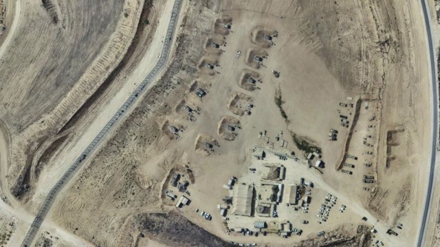
Gaza, Sep 26 (V7N)- Israel inadvertently published high-resolution images of several areas in Gaza on its official mapping platform, briefly revealing locations of Israeli military bases and extensive destruction across the enclave.
The glitch on Israel's GovMap platform was first reported Monday, September 21, by an X account specializing in open-source intelligence and the geolocation of events in Gaza, according to a report by UK-based Middle East Eye.
The clear satellite images reportedly remained available for a short period before Israeli authorities removed them from the platform. Blurred versions of the same areas were subsequently uploaded.
Another user reportedly saved copies of the images before they were removed. The images were later published on Soar Atlas, a platform that shares satellite imagery and other geospatial data.
The images showed widespread destruction in northern Gaza, including areas of Beit Lahia and Beit Hanoun, where large numbers of buildings and roads have been damaged or destroyed during Israel's military operations.
According to the report, the imagery also revealed at least 11 Israeli military bases, along with military vehicles, in areas identified as being within the buffer zone.
Similar satellite imagery reportedly showed military installations in the Zeitoun and Jabalia areas of Gaza City.
Israel has generally restricted the public release of detailed information about its military operations and the locations of sensitive installations.
The latest incident has drawn attention to the extent of destruction in northern Gaza and the exposure of military facilities through publicly accessible mapping imagery.
According to Palestinian health authorities, Israel's military offensive in Gaza has killed and injured tens of thousands of Palestinians since October 2023, while UN assessments have documented extensive damage to buildings and critical infrastructure across the enclave.
END/SMA/AJ